
What Does AVL Stand For and How Does It Save Lives
So, what exactly is Automatic Vehicle Location, or AVL? On the surface, it’s a simple acronym for a technology that tracks vehicles. But for any organization with people and equipment out in the field, it’s the key to real-time operational awareness—the difference between flying blind and having a clear picture of everything that’s happening.
Unpacking the Meaning of Automatic Vehicle Location
At its core, Automatic Vehicle Location is a system that answers one of the most fundamental questions for any mobile operation: "Where are my resources right now?" It's not just a single tool; think of it more like the central nervous system for your fleet. It takes what could be a chaotic collection of moving vehicles and turns them into an intelligent, coordinated force.
This technology gives you the real-time visibility needed to make smarter, faster, and safer decisions on the fly. Whether you're running an emergency response team or a logistics company, AVL provides the foundation for building efficiency and safety. It’s all about turning raw location data into genuinely useful intelligence.
The Core Purpose of AVL
The main goal of any AVL system is pretty straightforward: improve operational control. It gets this done through a few key functions:
- Real-Time Tracking: You get a live view of every vehicle and person on a digital map. No more guessing.
- Enhanced Dispatching: Dispatchers can see exactly who is closest and send the most appropriate unit to a call or job, cutting down on wasted time.
- Improved Safety: By monitoring where your assets are, you can ensure your people are safe and send help immediately if something goes wrong.
- Data-Driven Decisions: It’s not just about the "now." AVL collects historical location data you can analyze later to find better routes, spot inefficiencies, and improve overall performance.
A Game-Changer for First Responders
Automatic Vehicle Location is a critical technology that has completely changed the game for emergency services since GPS became widely available in the 1990s. By providing real-time tracking, it helps slash response times when every second counts.
In fact, it’s become the standard. In major markets like the US and Europe, over 80% of large fire departments now rely on AVL-enhanced systems to coordinate their teams and keep everyone safer. You can dig into some of the data on the impact of AVL on public safety if you're curious.
This widespread adoption just goes to show how valuable it is. Knowing the precise location of an ambulance, fire engine, or police car can make a life-or-death difference. For us at Resgrid, this capability is central to our mission of helping organizations manage their critical operations. To see what drives us, you can learn more about the mission behind Resgrid's platform.
The true power of AVL isn't just knowing where a vehicle is, but understanding what that information allows you to do. It’s about turning location data into a life-saving, money-saving advantage.
To put it all in perspective, here's a quick breakdown of what AVL brings to the table.
Automatic Vehicle Location (AVL) at a Glance
| Component | Function | Primary Benefit |
|---|---|---|
| GPS/GNSS Receiver | Pinpoints the vehicle's precise geographic coordinates. | Accurate, real-time location data. |
| Cellular/Radio Modem | Transmits location data back to a central server. | Constant communication and updates. |
| Mapping Software | Displays vehicle locations on a visual map interface. | Immediate situational awareness. |
| Central Server | Processes and stores location data for analysis. | Historical data for reporting & optimization. |
This combination of hardware and software is what transforms a simple location ping into a powerful tool for command and control.
How Automatic Vehicle Location Actually Works
Let's pull back the curtain on how AVL systems do what they do. It might seem complex, but the whole thing boils down to a simple, looping question: "Where is my truck right now?" The system is in a constant cycle of pinpointing its location, phoning that information home, and then showing it to you on a map.
Think of the GPS satellites orbiting the Earth as a grid of lighthouses in the sky. They're constantly beaming out signals with super-precise timestamps. The AVL device tucked away in a fire engine or an ambulance is like a ship's navigator. It listens for these signals from several satellites at once and, through a process called trilateration, calculates its exact spot on the globe.
Once the unit knows its latitude and longitude, it has to report in. Using a built-in cellular modem (just like the one in your phone), it zips that little packet of data over the 4G or 5G network back to a central server. This server is the harbor master, collecting location pings from every single vehicle in your fleet.
The flow is really that straightforward.
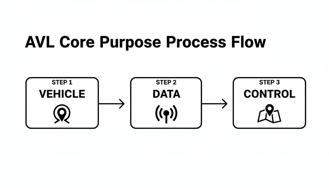
As the chart shows, the vehicle figures out where it is, turns that into data, and sends it to a control point where you can see it and make decisions.
The Key Components of an AVL System
This entire process hinges on a few key pieces of hardware and software all working together. Knowing what they are helps you understand how that dot moves across your dispatch screen.
- GPS/GNSS Receiver: This is the box in the vehicle that's listening for satellite signals. You'll hear GPS used all the time, but the more accurate term is GNSS (Global Navigation Satellite System). GNSS is an umbrella term that includes the American GPS, the Russian GLONASS, and Europe's Galileo systems, which gives the receiver more "lighthouses" to listen to for a better fix.
- Data Modem: This is what sends the location data back to base. Most systems use a cellular modem because it's cost-effective and coverage is widespread. For truly remote operations where cell towers are nonexistent, satellite modems are an option, but they come with a higher price tag.
- Central Server & Software: This is the brain of the whole operation. A central server takes in all the location data from your fleet, processes it, and stores it. Then, dispatch software—like what we've built into the Resgrid platform—takes that raw data and puts it on a map in a way that’s easy to understand at a glance.
Fine-Tuning Location Updates with Ping Rates
A critical setting you'll encounter is the "ping rate." This simply means how often a vehicle reports its location. It's not a set-it-and-forget-it number; you adjust it based on what the vehicle is doing to strike the right balance between real-time accuracy and data costs.
The right ping rate is all about context. A faster ping gives you a smoother, more detailed picture of movement, but it chews through more cellular data, which can drive up costs. The trick is to match the frequency to the urgency of the mission.
Practical Example: For a police cruiser involved in a high-speed pursuit, you need that near-constant update. You'd set its ping rate to every 1-5 seconds to give command a smooth line on the map.
Actionable Insight: On the other hand, a city bus just needs to provide reasonable arrival estimates, so a 60-second ping rate works perfectly. A municipal snowplow clearing routes during a blizzard? It might only need to check in every 5-10 minutes. This small adjustment dramatically cuts down on cellular data usage over a long winter season, directly saving money on your service plan. Dialing in the right ping rate is one of the easiest ways to control the ongoing costs of your AVL system.
The Life-Saving Impact of AVL on Emergency Response
When seconds can mean the difference between life and death, technology has to do more than just track a dot on a map. This is where Automatic Vehicle Location (AVL) really proves its worth, translating raw location data directly into life-saving action. Its biggest impact in emergency services is enabling closest-unit dispatch—a fundamental shift from the old way of doing things.
![]()
Instead of relying on rigid, predefined zones, a dispatcher with an AVL-powered map sees the real-time position of every single ambulance, fire engine, and police car. When a critical call comes in, there’s no guesswork. They can instantly identify and dispatch the unit that is physically closest, factoring in live traffic and road conditions.
Slashing Response Times When It Matters Most
Practical Example: Think about a cardiac arrest. For every minute that passes without CPR and defibrillation, a person's chance of survival plummets by 7-10%. Just shaving 30-60 seconds off a response time by sending an ambulance that is two blocks closer, instead of one across town, can dramatically change the outcome for that person. AVL makes this possible by ensuring the nearest paramedic unit is always the one sent to the scene.
The same logic applies to a structure fire, where a fire can double in size every minute. A faster response means firefighters arrive when the blaze is smaller and more manageable. This doesn't just reduce property damage; it saves lives.
The core benefit of AVL in emergencies isn't just about speed; it's about precision. It replaces assumptions with certainty, ensuring the right resources get to the right place in the shortest possible time.
Beyond just getting to the scene faster, AVL also directly enhances the safety of the first responders themselves. It acts as an "eye in the sky," giving dispatch a constant, reliable location for every officer and firefighter in the field. If a unit suddenly stops responding to radio calls, dispatch knows their exact location and can send backup immediately.
Improving Situational Awareness and Resource Management
During large, chaotic incidents like a multi-vehicle pile-up or a natural disaster, an incident commander needs a clear operational picture to make good decisions. AVL provides exactly that by showing where every single resource is deployed. This level of situational awareness allows commanders to:
- Prevent unit stacking: Avoids sending too many units to one spot while leaving other areas uncovered.
- Establish perimeters: Quickly set up and monitor cordons by viewing unit positions in real-time.
- Track personnel: Ensure all team members are accounted for in hazardous environments.
The data generated by AVL systems also offers a powerful tool for proactive public safety. A landmark study evaluating AVL in policing found that at designated hot spots, its use led to a 20 percent relative decline in crime. The researchers attributed this to more effective patrol allocation based on real-time and historical location data. You can dig into the full findings to understand AVL's role in crime reduction.
Actionable Insight: By analyzing historical AVL data from past incidents, departments can spot response gaps and optimize patrol routes. This not only improves public safety but also leads to significant fuel savings by cutting down on unnecessary mileage and engine idle time. Using AVL data for post-incident analysis transforms it from a real-time tool into a strategic asset for long-term planning and budget optimization.
Practical AVL Use Cases Beyond Sirens and Lights
While Automatic Vehicle Location (AVL) is a huge deal for modern emergency response, its value goes way beyond the flashing lights of a police car or ambulance. It turns out, the same ideas—real-time tracking and crunching that location data—are incredibly powerful for boosting efficiency and cutting costs in just about any business with wheels on the ground.
![]()
Practical Example: Picture a logistics company with a fleet of delivery trucks. An AVL system lets a dispatcher spot a traffic jam on the interstate in real-time and immediately reroute a driver onto a side road to avoid getting stuck. It’s a simple move, but it saves fuel, cuts down delivery times, and ultimately keeps customers happy. For some businesses, that can add up to thousands saved in fuel costs every year.
Improving Public and Commercial Operations
Public transit is another great example. Transit authorities use AVL to give commuters those super-accurate, up-to-the-minute bus arrival times right on their phones. This small convenience makes a massive difference in customer satisfaction and ridership. In fact, a major study found that over 70% of US transit agencies saw better operations after bringing in AVL, mostly because they wanted to improve customer service with reliable on-time tracking. You can dig into the findings on AVL in public transit for more details.
The applications are everywhere, touching nearly any industry that has assets out in the field:
- Construction: A construction firm can keep tabs on expensive heavy machinery like excavators and bulldozers. This helps stop theft—a huge problem in the industry—and lets them track engine hours to schedule maintenance before a costly breakdown happens.
- Event Management: For a big music festival, an organizer can manage security patrols across the entire grounds. With AVL, they can make sure every zone is covered and dispatch personnel to an incident in a heartbeat.
- Field Services: An HVAC company can see all its technicians on a map and send the closest one to an urgent service call, meaning they can get more jobs done each day.
The Actionable Insight Saving You Money
Actionable Insight: The single most powerful way for any business to get value from AVL is by running a fleet efficiency audit. This isn't some complicated, drawn-out process. It's really just about letting the data show you exactly where money is being wasted.
By looking at your historical AVL data, you can uncover hidden costs that are quietly draining your budget. Things like route replays and idle time reports give you a clear, undeniable picture of what your fleet is actually doing every day.
For example, you might run a report and find one driver consistently idles their truck for 30 minutes longer than everyone else during lunch, burning through gallons of fuel every week. Or maybe a delivery route is just plain inefficient, racking up unnecessary overtime pay. Tools like the Resgrid mobile apps for tracking provide this exact kind of personnel and unit location data, letting you pinpoint these wasteful habits. This data gives you a clear and direct return on your investment, turning the cost of an AVL system into a real source of savings.
Your Practical Checklist for Implementing AVL
Bringing an Automatic Vehicle Location (AVL) system into your organization is a huge step forward, but you need a clear plan to avoid a rocky rollout. If you think through the key steps beforehand, you can get a system that delivers value right away instead of causing headaches. This checklist will walk you through the process, from picking the right gear to getting your whole team on board.
The first big decision you have to make is what kind of tracking hardware you'll use. This isn't a one-size-fits-all situation; what works best really depends on how you operate and what your budget looks like.
- Vehicle-Mounted Units: These are the rugged, hardwired devices that get installed right into your vehicles. They’re perfect for dedicated assets like fire engines, ambulances, or delivery trucks because they’re always powered on and give you extremely reliable, tamper-proof tracking.
- Smartphone-Based Tracking: This approach just uses an app on a standard smartphone to report location. It’s incredibly flexible and much more cost-effective, especially for organizations that rely on volunteers or staff using their personal vehicles.
Securing Team Buy-In
Let's be honest, a new system is only as good as the team that uses it. To get everyone on board, you need to be transparent about the benefits. It's critical to frame AVL as a tool for safety and efficiency, not as "big brother" watching over their shoulder.
Practical Example: Explain how knowing a unit's exact location can save a life by letting dispatch send backup to the right spot, no questions asked. For other teams, show them how it cuts down on frustrating dispatch mistakes and helps spread the workload more fairly. When your people understand that AVL is there to help them do their jobs better and safer, they're far more likely to embrace it.
Making the Business Case with a Cost-Benefit Worksheet
Getting the budget approved often comes down to one question: what’s the ROI? This is where a simple Cost-Benefit Worksheet becomes your secret weapon. Instead of just guessing, you can build a powerful business case with real numbers.
The whole point of a Cost-Benefit Worksheet is to turn the efficiency gains from AVL into actual dollar savings. This makes the value of the system undeniable to the people holding the purse strings.
Actionable Insight: Here’s how you build one. First, list out all the upfront and ongoing costs for the AVL system you're considering. Then, start estimating the potential savings in a few key areas:
- Reduced Fuel Costs: Take a look at your current mileage and how much time your vehicles spend idling. Even a conservative 5-10% drop from better routing and less idling can add up to thousands in annual savings.
- Lower Maintenance Costs: AVL data often leads to better driving habits, which means less wear and tear on your fleet. Factor in what you could save on things like brake jobs, new tires, and other routine maintenance.
- Decreased Overtime Pay: When you can dispatch the closest unit and create more efficient routes using historical data, you can seriously cut down on unnecessary overtime. Calculate what that could save you based on what you're currently spending.
Once you tally up all those savings, you can clearly show how the AVL system won't just pay for itself, but will actually start generating a positive return for the organization.
Frequently Asked Questions About AVL Systems
Even after getting the basics down, you probably have a few practical questions kicking around. Let's tackle the most common ones so you can see how this technology fits into your day-to-day operations and budget.
How Much Does an AVL System Cost?
This is usually question number one, and the good news is, modern systems are more affordable than they've ever been. Typically, the cost is a mix of three things: the hardware itself, a software subscription, and any installation fees. But the days of needing a massive, five-figure check just to get started are pretty much over.
Actionable Insight: Here’s a real-world tip for saving money: look for flexible, modern platforms. Some providers, for instance, have a self-service model with no contracts. This lets you skip the huge upfront hardware costs by using the smartphones your team already has. For a small volunteer fire department or a growing business, this approach can save thousands of dollars a year while still delivering professional-grade tracking.
The biggest cost-saving opportunity today isn't haggling over hardware; it's choosing a software model that doesn't lock you into expensive, long-term contracts. Flexibility is the key to affordability.
Can AVL Track More Than Just Vehicles?
Absolutely. The core idea behind AVL—knowing where your resources are automatically—has grown way beyond just trucks and cars. Today’s systems can give you a complete operational picture by tracking personnel and critical assets right alongside your fleet.
Practical Example: Think about a large-scale event with security staff on foot patrol. With a simple app on their phones, a command center can see every guard's location in real-time. This ensures all zones are covered and lets them dispatch the closest person to an incident instantly. You can apply the same logic to valuable equipment, like portable generators on a construction site, by attaching small GPS trackers. It all comes together on a single, unified map showing all your critical resources, whether they're on wheels or on foot.
What About Employee Privacy Concerns?
This is a really important point, and it’s something to be taken seriously. The best way to handle privacy is with transparency and clear communication. The first step should be creating a formal, written usage policy that frames AVL as a tool for safety and operational support—not for micromanaging.
Practical Example: Focus on the benefits that directly help your people. For instance, explain that AVL is what lets dispatch send the closest backup unit to an officer in distress without a single word over the radio. Show a delivery driver how it proves they were on-site at the correct time, protecting them from customer disputes. When the team understands the technology is there to protect and support them, it builds trust and makes everyone more willing to get on board.
How Difficult Is It to Integrate AVL with Our Current Software?
It’s far easier than you might think. Most modern AVL platforms are built from the ground up with integration in mind. They use Application Programming Interfaces (APIs), which basically act like universal translators, letting different software systems talk to each other without any drama.
Actionable Insight: This means you can plug your AVL system directly into your existing Computer-Aided Dispatch (CAD) or records management software without a ton of expensive, custom coding. For example, a location ping from your AVL system can automatically update the unit location field in your dispatch software. That eliminates manual entry and cuts down on errors. This API-first approach gets you up and running faster and helps you sidestep the massive expense of building a custom software bridge from scratch.
Ready to see how a flexible, powerful, and contract-free AVL solution can transform your operations? Resgrid offers a comprehensive platform designed for first responders and businesses that integrates dispatch, messaging, and real-time tracking. Get started today at https://resgrid.com.