
What Is an AVL System A Practical Guide for First Responders
When you're running an emergency response operation, the single most critical question is often the simplest: "Where are my units right now?" An Automatic Vehicle Location (AVL) system gives you that answer, but it's so much more than just dots on a screen. Think of it as a live, tactical map of your entire fleet, showing you a dynamic picture of not just where your vehicles are, but their speed, direction, and current status.
What Is an Automatic Vehicle Location System
At its heart, an AVL system turns dispatching from educated guesswork into a science. It’s the difference between sending the unit you think is closest and knowing, with absolute certainty, which one can get to the scene the fastest.
This kind of real-time awareness isn't just about tracking for tracking's sake. It's a command-and-control tool that becomes the digital backbone for safer, more coordinated operations. For first responders, this means cutting down response times when every second counts. For any organization with a fleet, it translates directly into major cost savings.
Beyond Dots on a Map
An AVL system isn't just a single piece of hardware. It's a combination of devices and software all working in concert to deliver actionable intelligence. Picture it as a constant, reliable stream of information that gives decision-makers a clear, live view of every asset in the field.
This system gathers a few key data points that lead directly to smarter operations and a healthier budget:
- Real-Time Location: See exactly where every vehicle is on a live map, instantly.
- Vehicle Status: Know if a unit is en route, on-scene, or available for the next call.
- Speed and Direction: Monitor driving behavior to keep your team safe and compliant with department policies.
- Historical Data: Look back at past routes and response times to find patterns and opportunities for improvement.
Actionable Insight: The true value of an AVL system is its ability to turn simple location data into cost-saving action. By optimizing routes to steer clear of traffic or cutting down on unnecessary idling, organizations can slash fuel consumption by up to 15-20%. That adds up to thousands of dollars in savings every year.
To get a clearer picture of how these pieces fit together, let's break down the core components.
AVL System at a Glance
This table shows how each part of an AVL system plays a crucial role in delivering the real-time data you see on your screen.
| Component | Primary Function | Example in Emergency Response |
|---|---|---|
| GPS/GNSS Receiver | Pinpoints the vehicle's exact location on Earth. | A receiver in an ambulance calculates its precise coordinates. |
| Onboard Device | Collects GPS data and other vehicle info (speed, status). | The ambulance's onboard unit gathers location and speed data. |
| Communications Link | Transmits the collected data from the vehicle to a server. | A cellular or radio network sends the ambulance's data back to dispatch. |
| Backend Software | Processes the incoming data and displays it on a map interface. | The dispatch center software shows the ambulance moving on a map in real-time. |
As you can see, it's a seamless flow of information from the vehicle in the field straight to the command center, empowering dispatchers with the information they need to make the best possible decisions.
The Foundational Technology
The whole system is built on top of incredibly reliable positioning technology. If you want to dive deeper into the nuts and bolts, you can explore how it all works in Safety Assurance Technologies: The Role of NFC and GPS.
When you integrate this powerful location data into a platform like Resgrid, it becomes a central pillar of your entire dispatching and management workflow, creating one seamless operational picture.
How AVL Technology Translates Data Into Action
So how does a vehicle's actual position on the street make its way to your dispatch screen? It's a surprisingly straightforward three-step process that turns raw location data into a powerful tool you can use every day. This constant loop of information is the real engine behind any good AVL system.
First, a GPS or GNSS receiver installed in the vehicle is in constant communication with satellites orbiting the Earth, pinpointing its exact location. Think of it like the vehicle always knowing its own precise coordinates, often down to just a few feet. This is the bedrock data point that makes everything else work.
Next, a small communications device—usually cellular—sends this location data back to a central server. It often bundles in other key details like speed, heading, and vehicle status. It’s like the vehicle sending a constant, automated text message saying, "Here I am, and here’s what I'm doing."
Finally, a central software platform, like our own Resgrid system, catches this stream of information. It instantly processes the data and plots the vehicle's location on a digital map for dispatchers and commanders to see. This isn't just a delayed snapshot; it's a live, moving picture of your entire fleet in real-time.
This simple flow is how AVL gets critical data from the vehicle to your command center.
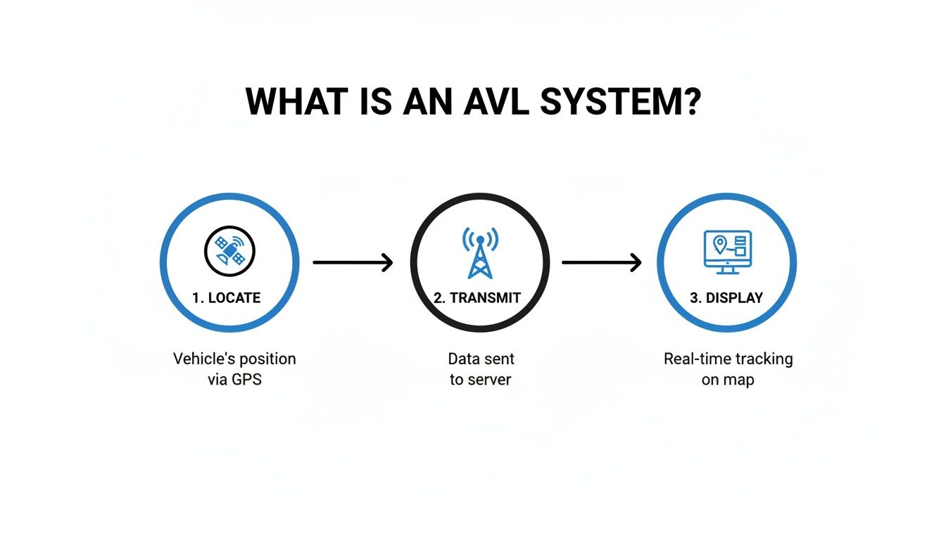
This constant cycle—locate, transmit, display—is what gives dispatchers intelligence that is always current. It’s the key to making smarter, faster decisions when seconds count.
From Raw Data to Real Savings
That locate-transmit-display loop is where the magic really happens. It’s how simple coordinates turn into insights that directly impact your budget. Every packet of data sent from a vehicle isn't just a dot on a map; it's a piece of financial and operational intelligence.
By looking at this data over time, you can spot expensive patterns you'd otherwise miss. For example, are your vehicles consistently idling for more than ten minutes at a time? That's just burning fuel for no reason. A good AVL system can flag this behavior automatically.
Actionable Insight: A single hour of unnecessary idling can burn through a gallon of fuel. For a fleet of 20 vehicles, cutting just 30 minutes of idle time per vehicle each day can save over $5,000 per year in fuel costs alone, assuming gas is $3.50 per gallon.
Practical Ways This Saves Money
The value becomes crystal clear when you see how this data translates into direct savings. Instead of relying on manual logs or just gut feelings, you have hard data to back up your decisions.
- Optimized Routing: Dispatchers can see live traffic and send units on the fastest, most fuel-efficient routes. This cuts down on mileage and reduces wear and tear. For example, during a city-wide event that snarls traffic, dispatch can see the gridlock and route an ambulance around it, saving fuel and critical minutes.
- Maintenance Alerts: Modern AVL systems track engine hours and mileage, automatically sending alerts when preventative maintenance is due. This helps prevent costly breakdowns and makes your vehicles last longer. For example, you'll get an alert that Engine 5 needs an oil change in 200 more miles, allowing you to schedule service before it becomes an emergency repair.
- Proof of Service: For agencies that bill for services, historical AVL data provides undeniable proof of when and where a unit was. This ensures accurate invoicing and shuts down potential disputes. For example, if a private citizen disputes a bill for a non-emergency transport, you can pull the AVL report showing the exact time and route the ambulance took.
This ongoing flow of information lets you make life-saving decisions based on precise, up-to-the-second intelligence instead of just relying on radio chatter and guesswork.
The Real-World Payoff of AVL for Emergency Services
It's one thing to understand the tech behind Automatic Vehicle Location (AVL), but it’s another to see what it actually does for your crew, your operations, and your budget. For first responders, the benefits aren't just about dots on a map—they create a ripple effect that makes everyone safer, cuts costs, and frankly, helps you do the job better.
The most obvious win? Slashing response times. With a live, accurate view of every unit, dispatch can send the absolute closest vehicle to a scene. No more guesswork based on static zones or "Where are you now?" radio calls. This alone can shave critical minutes off a response when every single second counts.
But the advantages run much deeper, right down to crew safety. A commander with a real-time overview knows exactly where every firefighter, medic, or officer is. During a big, chaotic incident, that kind of situational awareness is priceless. It’s a safety net, ensuring you can get backup to the right spot without a moment's delay.
Driving Down Costs and Upping Efficiency
Beyond the life-and-death moments, AVL is a powerhouse for tightening up day-to-day operations and finding serious savings. By seeing traffic patterns and road conditions in real-time, dispatch can route units around a jam or a roadblock. That smart routing adds up fast in lower fuel bills and less wear and tear on your rigs.
This same intelligence applies to keeping the fleet running. Instead of sticking to a generic maintenance schedule, AVL systems track actual engine hours and mileage, flagging units for preventative service when they actually need it. This proactive approach stops expensive, unexpected breakdowns in their tracks and helps you get more life out of your vehicles, saving a ton of money over the long haul.
Actionable Insight: We've seen mid-sized agencies cut their annual fuel bill by 15% or more just by using AVL data to curb speeding and reduce excessive idling. For a fleet burning through thousands of gallons a month, those savings can easily pay for the entire AVL system and then some.
Turning Raw Data Into Smarter Decisions
The historical data logged by an AVL system becomes an incredibly valuable tool for after-action reviews and future planning. It gives you a clear, second-by-second playback of a vehicle's movements, which is undeniable proof of service for billing disputes or legal questions.
This data also fuels strategic planning. By analyzing response times across different parts of your district, you can spot coverage gaps and reposition units to better serve the community. It turns your fleet's everyday movements into a roadmap for improvement. The technology fueling this is always getting better, with major players in the mobility space pushing it forward. Take AVL, a global leader in this tech—they saw their turnover jump by 18% in 2022 to 1.86 billion Euros. A huge chunk of that growth, 60%, came from work in automated driving and driver assistance systems. These are the kinds of innovations that make vehicles more reliable and safer, which is exactly what first responders need.
At the end of the day, AVL shifts your entire fleet management from being reactive to proactive. It means every decision is backed by solid data. This shift saves money, protects your people, and leads to better outcomes for the community you serve.
See AVL in Action: Practical Use Cases
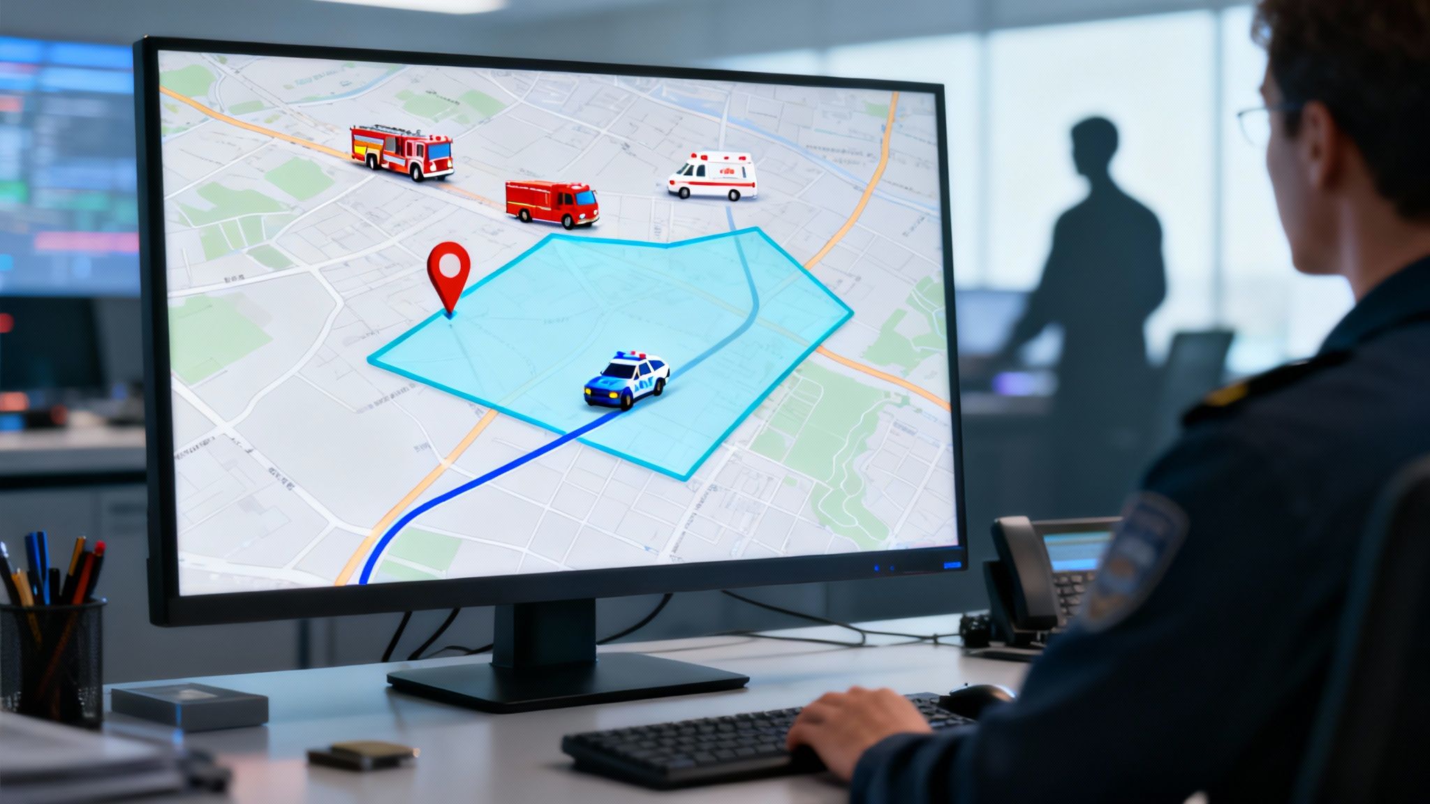
Theory is great, but the real "aha!" moment comes when you see how Automatic Vehicle Location (AVL) solves problems on the ground. This isn't just about dots on a map; it's a powerful tool agencies rely on daily to tackle unique operational hurdles, boost safety, and even save money.
Imagine a fire department battling a massive wildfire. With AVL, the incident commander gets a single, unified view of every engine, water tender, and command vehicle. They know instantly which units are on the fire line, which are heading back to refill, and which are staged and ready to go. This allows them to shift resources to the most critical areas with surgical precision.
For a police department, AVL adds a vital layer of safety and accountability. Dispatchers can create geofences—think virtual boundaries—around specific patrol zones. If a vehicle leaves its assigned area unexpectedly, an alert is triggered immediately, prompting a quick check-in to make sure the officer is okay.
Pinpointing Gaps and Improving Service
Let's talk about an EMS provider responsible for an entire city. Here, response times are everything. By digging into historical AVL data, managers can spot "hot spots" with high call volumes or uncover zones where response times are consistently lagging behind.
This isn't guesswork. It's data-driven insight that lets them strategically reposition ambulances during peak hours to cover those gaps. They're using hard data to make decisions that directly cut down response times and improve patient outcomes.
Actionable Insight: By repositioning just one ambulance based on historical AVL data, a municipal EMS service can reduce its average response time in a high-demand zone by as much as three to five minutes. That's a critical window in a medical emergency, and this adjustment costs nothing but delivers immense value.
Expanding Beyond Emergency Response
The practical uses for a solid AVL system stretch far beyond the usual first responders. Take a public works department during a major snowstorm.
By tracking their snowplow fleet with AVL, they can offer the public a real-time progress map online. This kind of transparency is huge for managing resident expectations and showing the department is on the job. Internally, managers can ensure all critical routes are cleared in the right order and that no street gets missed, turning a massive logistical headache into a well-oiled operation.
- Waste Management: Route optimization based on AVL data helps sanitation crews slash fuel costs. Trucks follow the most efficient paths, and overlapping service areas become a thing of the past.
- Public Transit: Transit authorities use AVL to give riders real-time bus arrival info. This simple feature dramatically improves the rider experience and can actually increase ridership.
- Utility Companies: When a power outage hits, AVL helps dispatchers send the closest repair crew to the scene. This means faster service restoration and less downtime for customers.
Each of these examples shows how AVL turns simple location data into a solution for a real-world problem. It’s a versatile tool that drives efficiency, enhances safety, and provides a clear return on investment across countless industries. Many of these functions can be tied together with integrated software, and you can explore the different apps available through Resgrid that help pull all this data together.
Implementing AVL in Your Organization
Rolling out an Automatic Vehicle Location (AVL) system doesn't have to be a monumental headache. With a clear plan, you can get this powerful technology into your fleet smoothly and start seeing the benefits almost immediately. It all starts with a few key decisions that will really set the foundation for your system's success.
The first piece of the puzzle is picking the right hardware for your fleet's specific jobs. What you need is going to vary wildly depending on the vehicle's role. For an administrative car, a simple, cheap plug-and-play OBD-II device is probably all you need. But for a frontline fire engine or an ambulance, you’ll want a rugged, hardwired system that’s deeply integrated with the vehicle—something built to last.
Building Your Foundation
Once you've got a handle on the hardware, the next big step is looking at your network and security. You need to make sure the cellular provider you go with has solid coverage across your entire response area. Pay special attention to those rural or remote zones where calls often take you. A tracker is useless if it can't phone home.
Data security is just as critical. Your AVL system is going to be handling sensitive operational information, so that data needs to be locked down. It's vital that the information is encrypted both when it’s flying through the air from the vehicle and when it’s sitting on the server. A secure system protects your operations, your apparatus, and your people.
Actionable Insight: Don't get locked into a single vendor's ecosystem. Choosing a flexible software platform like Resgrid that works with multiple hardware providers gives you freedom. You can pick the most cost-effective GPS devices for your needs, which could save you 30-50% on initial hardware costs compared to a bundled, proprietary solution.
Driving Adoption and Ensuring Success
A successful rollout is less about the tech and more about the people. Getting buy-in from your team from day one is absolutely crucial. You need to frame AVL as a tool for safety and efficiency, not as Big Brother watching over their shoulder. The key is to emphasize how real-time tracking means faster backup and better coordination when things get hairy.
To make sure things go smoothly, think about following these steps:
- Run a Pilot Program: Don't go all-in at once. Start with a small group of vehicles to work out any kinks in the system. This gives you a chance to test the hardware, the software, and your own internal processes on a manageable scale before you deploy it across the entire fleet.
- Create Clear Policies: Be transparent. Develop a straightforward usage policy that outlines exactly how AVL data will be used. Make it crystal clear that its purpose is for operational safety, smarter dispatching, and after-action reviews.
- Provide Thorough Training: Show your team how the system works. More importantly, show them the benefits that directly impact their safety and make their jobs easier. When they see the "why," they'll get on board.
The automotive world is always pushing forward, and these innovations make emergency vehicles more reliable than ever. For instance, the company AVL has been a pioneer since 1948, growing into a global leader that works on everything from autonomous driving to over-the-air updates that improve vehicle safety, all while sticking to strict standards like ISO 26262.
By carefully planning your hardware, buttoning up your data security, and communicating openly with your team, you can implement an AVL system that pays for itself right away. If you need any extra guidance, our team is always here to help. You can find more information by visiting our Resgrid support page.
Maximizing Your Return on Investment with Advanced Features
Think of an Automatic Vehicle Location (AVL) system as more than just a moving dot on a map. In reality, it’s a powerful data engine, one that can drive serious cost savings and make your entire operation run smoother. To really get your money's worth, you have to look past the real-time map and dig into the advanced features that turn raw data into dollars saved.
This is where advanced reporting and analytics come in. When you can look back at historical data, you start to see patterns you’d otherwise miss completely. Analyzing past trips, for instance, can help you find the most fuel-efficient patrol routes, potentially saving thousands of dollars a year. It's the first step toward smarter, more strategic fleet management.

Unlocking Actionable Insights
One of the best money-saving tools in the AVL toolkit is driver behavior monitoring. You can set up automated alerts for things like excessive idling or speeding, which directly cuts down on fuel costs and makes your team safer. An alert can ping a manager when a vehicle has been parked with the engine on for more than 10 minutes—a simple notification that prompts a quick correction and stops fuel waste in its tracks.
Actionable Insight: Instead of guessing when a vehicle needs service, you can schedule preventative maintenance based on actual mileage and engine hours tracked by the AVL system. This proactive approach prevents costly breakdowns and can extend a vehicle’s life by 15-20%, pushing back expensive replacement purchases.
These metrics also give you the hard data you need to justify budget requests. It’s one thing to ask for money; it’s another to show the city council a report detailing a 10% reduction in fuel consumption right after implementing new policies based on AVL data. That makes your argument a whole lot more convincing.
Leveraging Data for Strategic Decisions
The data flowing from your AVL system empowers you to make smarter, evidence-based decisions. And these tools are only getting better. Industry leaders are pouring resources into developing more sustainable and efficient technologies. In fact, 60% of AVL's turnover in 2022 came from innovations in electrification and automated driving.
Their commitment is backed by serious investment, like a 204.6 million Euro R&D budget that same year, which brings smarter and greener tech to fleets. For first responders who depend on top-tier efficiency and safety, this is a huge deal.
By using these advanced features, your system stops being just a tracking utility and becomes a core strategic asset. You can explore a full suite of these kinds of reporting and management tools by checking out the features available in Resgrid.
We Get These Questions All The Time
Rolling out new tech always brings up questions. It's just part of the process. When it comes to something as important as knowing where your units are, you need to be sure about the costs, privacy, and how it all works in the real world. Let's tackle the big questions we hear most often.
So, How Much Does This Actually Cost?
The price tag can swing a bit depending on the hardware you go with and how many vehicles you're outfitting. But honestly, modern AVL systems pay for themselves, and usually pretty quickly.
You're looking at an upfront hardware cost, maybe $50 to over $200 per vehicle for the little GPS box itself. After that, there's a monthly software and data fee, which usually lands somewhere between $15 and $30 per vehicle. But the real story isn't the cost; it's the savings. We've seen departments save thousands a year just from cutting down on fuel, optimizing maintenance, and getting staffing right.
Actionable Insight: Platforms like Resgrid are designed to get you up and running without those soul-crushing setup fees or getting you tangled in long-term contracts you can't get out of. Look for clear, simple pricing that scales with you. That's how you get the benefits without breaking the bank.
Is This Some Kind of "Big Brother" Tracking?
That's a fair question, and one you need to get out in front of with a clear, honest policy. The key is to frame AVL for what it is: a tool for safety and efficiency, not a way to spy on your people.
Your policy needs to state, flat out, that tracking is for official use during work hours. It's there to make sure backup can get to you fast, to send the closest unit to a call, and to confirm everyone's location during a major incident. Once your team understands the system is there to protect them, you'll see buy-in go way up.
What if We Work in Areas with Spotty Cell Service?
This is a make-or-break issue for a lot of agencies, and it's something modern AVL systems are built to solve. Many GPS devices now come with what's called "store and forward" technology.
It's pretty simple: if a vehicle drives out of cell range, the device just saves all the location pings. The moment it reconnects to the network, it uploads the entire breadcrumb trail. It's like it was never offline.
For crews that are constantly in remote areas, you can step up to dual-mode hardware. These units use both cellular and satellite networks to guarantee a connection. Satellite data costs a bit more, but it means you will never lose track of a critical asset, no matter where they are.
Ready to see how a flexible, powerful AVL system can transform your operations? Resgrid offers a unified solution for dispatching, messaging, and real-time tracking without expensive contracts or setup fees. Learn more and get started at Resgrid.com.