

Computer Aided Dispatch Police Systems That Boost Response
Think of a police computer aided dispatch (CAD) system as the digital nervous system for any law enforcement agency. It’s the critical piece of software that takes the chaos of a 911 call and turns it into a structured, manageable response. From the moment that first call comes in, the CAD system is processing information, analyzing data, and coordinating the entire police operation.
How a Police CAD System Actually Works
If a police department's command center is its brain, then the Computer Aided Dispatch system is the high-speed network connecting that brain to every officer, vehicle, and critical piece of information out there. It serves as a digital backbone, ensuring every single action is informed, tracked, and carried out efficiently.
At its heart, a modern police CAD system runs on the seamless flow of information, functioning through advanced real-time data streaming. It doesn’t just take notes on calls; it intelligently manages the entire lifecycle of an incident, from the initial report all the way to its final resolution.
This process map shows the simplified journey from a 911 call to an officer being dispatched—all orchestrated by the CAD system.
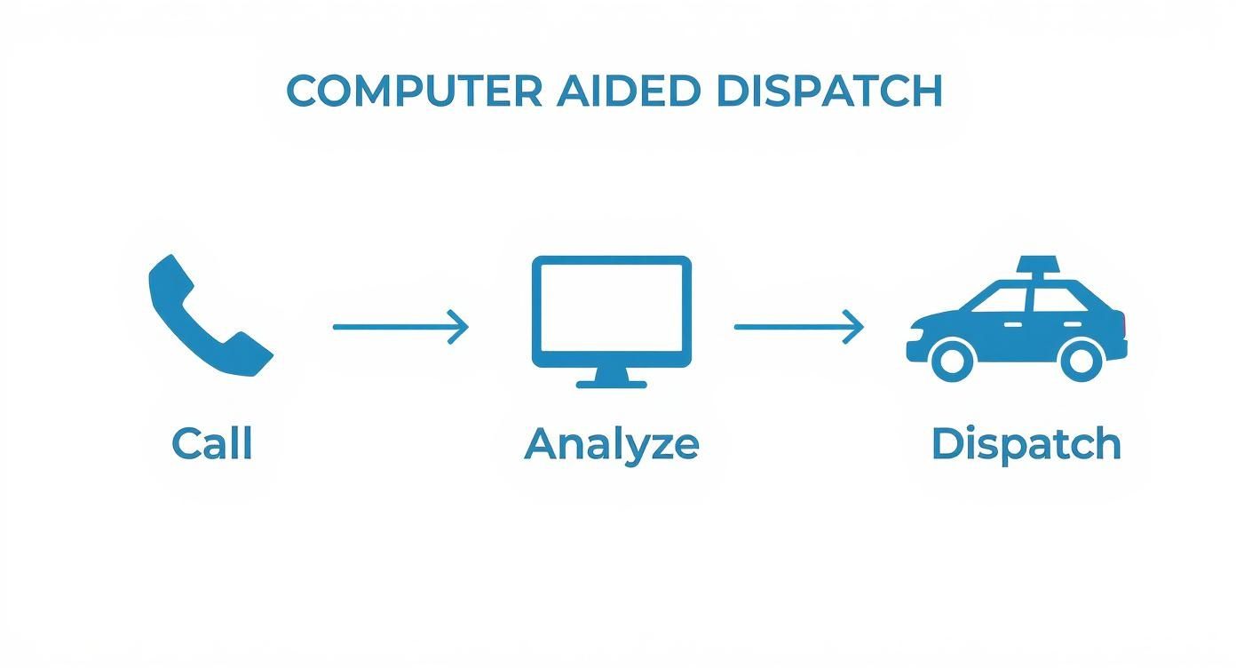
As you can see, the CAD system is the central hub, turning a raw, often frantic, emergency call into a swift and organized police action.
To get a clearer picture of its role, let's break down the essential functions a CAD system handles from start to finish.
Core Functions of a Police CAD System at a Glance
| Function | Description | Practical Example |
|---|---|---|
| Call Taking & Logging | Captures and records all initial information from an incoming emergency call. | A dispatcher enters details from a 911 call about a burglary in progress, including the address and suspect description. |
| Data Verification | Uses integrated systems like GIS to confirm the accuracy of location and other data. | The system auto-verifies the caller's address on a map and flags potential discrepancies. |
| Unit Status Tracking | Provides a live overview of every officer's location, availability, and current assignment. | A dispatcher sees three units are "Available," one is "On Scene" at another call, and two are "En Route." |
| Dispatch Recommendation | Suggests the most appropriate and closest available units for a specific incident. | For a high-priority call, the CAD recommends the two closest patrol cars and the nearest K-9 unit. |
| Incident Management | Acts as the central repository for all updates, notes, and events related to an active incident. | Officers provide updates via their mobile terminals, which are automatically logged in the incident file. |
| Reporting & Analytics | Compiles data from past incidents to generate reports for analysis, training, and resource planning. | A police chief runs a report on response times in a specific district over the last six months. |
This table just scratches the surface, but it highlights how the CAD system is far more than a simple logging tool—it's an active partner in the entire response process.
The Initial Call and Data Analysis
The second a call hits the dispatch center, the CAD system gets to work. The dispatcher starts entering the basic details—what's happening, where it's happening, and any descriptions the caller provides. But this is where modern systems really shine.
Instead of just being a digital notepad, the system instantly starts analyzing the incoming data:
- Location Verification: It leverages GIS mapping to nail down the exact location, often double-checking it against cell tower pings or GPS data to get it right.
- Resource Availability: A live map pops up, showing the real-time position and status of every single patrol unit. Dispatchers know instantly who’s free, who’s busy, and who's closest to the new call.
- Incident Prioritization: Using pre-set protocols, the system helps the dispatcher classify the call's severity, making sure life-threatening emergencies get the immediate, full-force response they need.
Intelligent Dispatch and Coordination
Once the initial data is crunched, the system helps the dispatcher make the best possible assignment. It might automatically suggest the three closest available units, or flag specialized officers like K-9 or tactical teams if the situation calls for them. This feature alone shaves critical seconds off response times and even saves money by reducing fuel use and sending the most logical unit.
The system becomes the single source of truth for the entire operation. It gives everyone involved—from the chief back at headquarters to the officer arriving on the scene—a clear, shared, and constantly updated view of the situation as it unfolds. It’s this digital coordination that has truly changed the game for police and emergency response.
The Journey from Radio Logs to Smart Dispatch
Before computer aided dispatch police systems showed up, dispatch centers were a scene of controlled chaos. Just picture it: a cluttered desk piled high with paper logs, the constant crackle of radio transmissions, and a huge wall map covered in pins marking out officers and incidents. For decades, that was the reality.
In that manual world, a dispatcher’s two most vital tools were their own memory and a grease pencil. A call would come in, they’d scribble notes on a card, squint at the pin map to guess which officer was closest, and then broadcast the details over the air. It worked, sure, but the whole voice-only system was riddled with delays and missing information.
There was no way to instantly check if an address was valid, no live view of an officer's exact location, and no digital trail of an incident as it was happening. Information was scattered all over the place, and the risk of human error was huge—often costing precious seconds when it mattered most.
From Pins on a Map to Pixels on a Screen
The first digital CAD systems started to flip the script. They swapped out paper logs for electronic records, which created a searchable history of calls and responses. This was a massive step forward, but these early systems were often just glorified digital card files, lacking the real-time smarts we have today.
The real game-changer came when two key technologies were integrated, both of which are now standard in any modern police CAD system:
- Geographic Information System (GIS) Mapping: This is what finally replaced the physical wall map with a dynamic, digital version. Dispatchers could suddenly see an incident's location instantly, verify addresses on the fly, and spot critical landmarks or potential hazards.
- Automatic Vehicle Location (AVL): By putting GPS trackers in patrol cars, CAD systems could finally show the real-time position of every single unit. The guessing game was officially over; dispatchers knew exactly who was closest and available to respond.
This combination was more than just an upgrade; it fundamentally changed how public safety was managed. It turned dispatch from a reactive call-taking center into a proactive, intelligent command hub.
This shift to data-driven dispatch arms officers with crucial intelligence before they ever arrive on scene. Knowing the incident history of an address or seeing the real-time movement of other responding units drastically improves situational awareness and officer safety.
The Rise of the Modern Smart Dispatch Hub
Today's computer aided dispatch police software is a huge leap from those early days, connecting dispatchers, officers, and data in ways that were once pure science fiction. The system now acts as the central brain, pulling in information from all over to paint a complete operational picture for everyone involved.
You can see just how critical this technology has become by looking at the investment pouring into it. The global market for CAD was valued at around USD 2.8 billion as of 2024, a number being pushed higher by nationwide public safety initiatives. And it’s not slowing down—projections show the market is expected to climb to nearly USD 4.9 billion by 2030. You can explore more data about the growing CAD market and its future trends.
This growth is all about the demand for smarter, safer, and more efficient policing. Modern systems now talk directly to the mobile data terminals in patrol cars, letting officers get incident updates, see maps, and file reports right from the field. This saves an unbelievable amount of time and money by cutting out trips back to the station for paperwork. By automating those admin tasks, CAD frees up personnel to focus on more visible, proactive community policing—a direct cost-saving benefit that also boosts public trust.
Key Features of Modern Police CAD Systems
Modern computer-aided dispatch police systems are a lot more than just digital notepads for 911 calls. They’ve evolved into powerful operational hubs, packed with tools that work together to turn raw data into actionable intelligence. When you understand how these components click together, you see how technology gives officers on the ground a real edge.
Automated Vehicle Location (AVL)
One of the biggest game-changers is Automated Vehicle Location (AVL). Think of it as a live, tactical map showing you the real-time position of every single police vehicle. This isn't just about dots on a screen; AVL is a smart dispatch tool.
When a high-priority call comes in, the system uses AVL data to instantly flag the closest available units. This cuts out the guesswork for dispatchers and shaves critical seconds—sometimes even minutes—off response times.
This screenshot from a Next Generation 911 (NG911) project shows just how crucial it is for different systems, including CAD, to talk to each other to keep information flowing smoothly.
As the diagram illustrates, a modern CAD system has to be interconnected. Its best features can't exist in a vacuum; they have to pull data from everywhere to be truly effective.
Integrated GIS Mapping
Building right on top of AVL is Integrated Geographic Information System (GIS) Mapping. This feature brings the operational map to life with rich, layered data that’s absolutely indispensable during an emergency.
Instead of a basic street map, dispatchers and officers get a dynamic view of the environment. With GIS baked in, they can see:
- Critical Infrastructure: Pinpointing the locations of schools, hospitals, and government buildings.
- Hazards: Flagging known hazardous material sites or areas that are prone to flooding.
- Real-Time Conditions: Getting live traffic data, road closures, and even weather overlays.
- Premise History: Accessing notes on previous calls to a specific address, like known threats or vulnerable residents.
Picture this: A dispatcher gets a call about a fire at a chemical plant. With integrated GIS, they can immediately see a pre-plotted evacuation route, identify the specific chemicals stored on-site, and direct responding units away from potential explosion zones. All within seconds.
This level of detail delivers incredible situational awareness, paving the way for smarter, safer response strategies before the first officer even arrives on the scene.
Seamless Records Management System Integration
From a pure officer safety perspective, the link between the CAD system and the Records Management System (RMS) might be the most vital feature of all. While CAD handles the live incident, the RMS is the agency's long-term digital library—it stores every police report, arrest record, and piece of investigative data.
When these two systems are seamlessly connected, information flows instantly. An officer can run a license plate from their patrol car and, through the CAD's link to the RMS, immediately get alerts about the vehicle owner's history. We're talking prior arrests, known associates, or active warrants.
It's a two-way street, too. Once an incident is over, data from the CAD call—times, locations, involved parties—can automatically populate a new report in the RMS. This can save officers dozens of hours a week on paperwork, freeing them up for proactive patrols. The cost savings from that reduced administrative time alone can be massive. If you want to dig deeper into how these efficiencies work, you can learn more about the diverse feature sets available in today's dispatch platforms.
Comparing Legacy CAD vs Modern CAD Features
To really grasp the leap forward, it helps to see the old and new side-by-side. The table below breaks down the key differences between the clunky systems of the past and the integrated powerhouses agencies use today.
| Feature | Legacy CAD System (Pre-2000s) | Modern Police CAD System | Primary Benefit of Modernization |
|---|---|---|---|
| Location Tracking | Manual voice updates from officers | Real-time AVL showing every unit's exact position | Faster dispatch recommendations and improved officer safety |
| Mapping | Static, 2D street maps with limited detail | Dynamic, layered GIS maps with live data overlays | Unprecedented situational awareness and smarter response planning |
| Data Access | Disconnected systems; required radioing dispatch for info | Seamless RMS integration for instant background checks | Proactive threat assessment and enhanced officer safety |
| Reporting | Manual, paper-based reports filled out post-incident | Mobile field reporting directly from the vehicle | Drastically reduced administrative time and more time on patrol |
| Inter-Agency Communication | Phone calls and radio chatter; often slow and unreliable | Built-in interoperability for multi-agency data sharing | Coordinated responses during large-scale or cross-jurisdictional events |
| User Interface | Text-based, command-line interfaces requiring extensive training | Intuitive, graphical user interfaces (GUIs) | Reduced training time and fewer user errors |
| System Updates & Maintenance | On-premise servers requiring manual updates and costly hardware | Cloud-based (SaaS) with automatic updates and scalability | Lower IT overhead, better reliability, and access to the latest features |
As you can see, the shift isn't just about a prettier interface; it's a fundamental change in how information is gathered, shared, and used to protect communities and first responders.
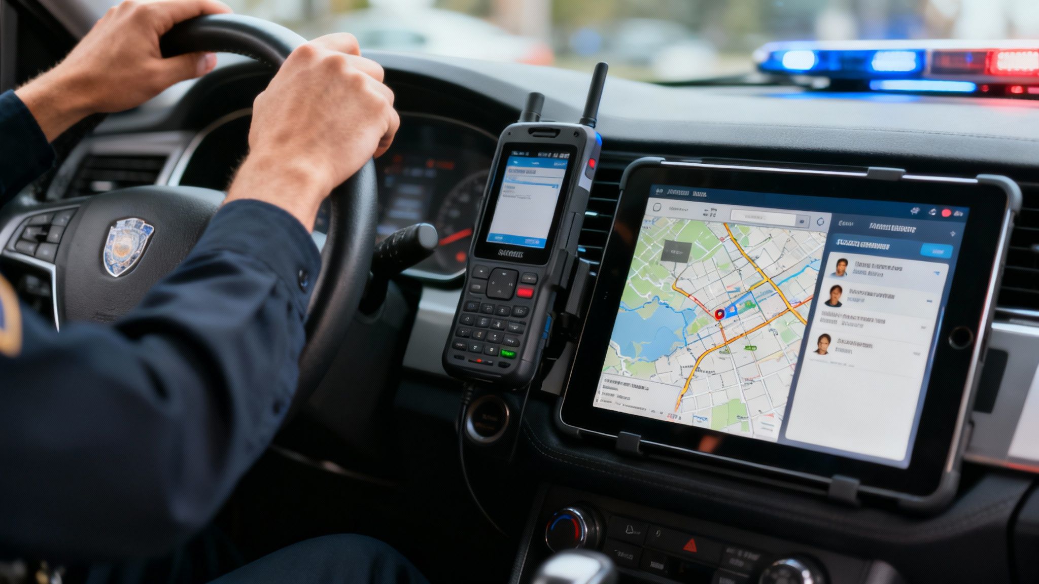
Mobile Data Terminals and Field Reporting
Modern CAD systems don't stop at the dispatch center. They extend directly into the hands of officers through Mobile Data Terminals (MDTs) in their vehicles. These ruggedized laptops or tablets are an officer's lifeline to the CAD system, feeding them a constant stream of information.
From their MDT, an officer can:
- Get silent, text-based dispatch updates without tying up the radio.
- See the same GIS maps the dispatcher is looking at, complete with all the call details.
- Chat with other units through secure messaging.
- Start filling out incident reports right from the scene.
This mobile connection is a massive efficiency booster. An officer can clear a minor call and start the report while still in the field, making themselves available for the next incident almost immediately. It's all about reducing downtime and keeping more officers actively patrolling their communities.
How CAD Delivers Real Cost Savings and Better Safety
A modern computer aided dispatch police system is much more than just an operational tool. Think of it as a strategic investment, one that pays real, tangible dividends in both dollars and public safety. For agency leaders and city managers, the case for upgrading to an intelligent CAD platform is built on a rock-solid foundation of financial benefits and measurable improvements in officer and community safety.
Right off the bat, the most impactful savings usually come from smarter resource management. Traditional dispatch methods can be clumsy, often sending units based on old-school zone boundaries instead of who’s actually closest. This approach burns fuel, puts unnecessary wear and tear on vehicles, and ultimately, slows down response times.
Intelligent dispatch algorithms change the game completely. They use live AVL data to pinpoint and recommend the absolute closest, most appropriate unit for any given call. It sounds like a small tweak, but this one change creates a ripple effect across an agency's entire budget.
Slashing Operational Costs Through Efficiency
When you optimize dispatch routes, you directly cut down on fuel consumption and mileage—two of the biggest recurring expenses for any patrol fleet. By making sure the most efficient unit is always sent, agencies can reduce vehicle maintenance bills and get more life out of their patrol cars.
But the savings go way beyond the vehicles. A modern CAD system is a beast at automating mind-numbing administrative tasks. It's shocking how much of an officer's shift can be eaten up by paperwork, manually punching in incident data into one system after another.
This is where a seamless link between CAD and a Records Management System (RMS) becomes a financial game-changer. The benefits are immediate:
- Reduced Administrative Overhead: Incident data from the CAD system flows directly into RMS reports. For many officers, this cuts data entry time by more than half.
- More Time on Patrol: Freeing up sworn officers from hours of paperwork means they can spend more time on proactive patrols and engaging with the community. It’s like getting a force multiplier without having to hire more staff.
- Fewer Data Entry Errors: Automation ensures the data is consistent and accurate from the start, which cuts down on the time and money spent fixing clerical mistakes later on.
Looking into different system capabilities can show you which solution offers the best bang for your buck. To see how these features stack up at different investment levels, you can review details about dispatch software pricing and plans and find a fit for your agency's budget.
Preventing Over-Deployment and Enhancing Safety
Over-deployment is another huge financial drain. This happens when you send more units than a call really needs, usually because of incomplete information. A modern CAD gives dispatchers rich, contextual data, including premise history and real-time updates from the field, allowing them to make much more calibrated decisions. This stops them from tying up valuable resources on low-priority calls, keeping those units free for real emergencies.
This smarter allocation doesn't just save money; it makes everyone safer. When a high-priority call like an active shooter or a home invasion comes in, every single second is critical.
By ensuring that resources aren't needlessly tied up elsewhere, a CAD system guarantees that life-threatening emergencies get the fastest and most robust response possible. That's the ultimate return on investment.
This capability is so vital that it's driving major government investment in public safety tech. For example, sustained government funding, like the USD 370 million the US Department of Justice granted in 2022 for law enforcement tech upgrades, shows just how important these systems are. These platforms are proven to slash response delays and smooth out coordination between police, fire, and EMS. You can discover more insights about these technology grants and see the impact for yourself.
Justifying Budgets with Hard Data
Finally, a computer aided dispatch police system is one of the best tools you can have for securing future funding. The platform meticulously logs every piece of operational data—from call volumes and incident types to unit response times and geographic hotspots. This mountain of hard data is powerful evidence when you're standing in front of a council presenting a budget request or applying for a grant.
Instead of relying on stories and anecdotes, police chiefs and city managers can present clear, data-driven reports that pinpoint specific needs. They can show exactly where more resources are required, justify overtime expenses with solid incident data, and prove that past investments have paid off. This turns budget discussions from subjective debates into objective, data-backed conversations, making it far easier to get the funding you need to keep your community safe.
Choosing the Right CAD System for Your Agency
Picking a new computer aided dispatch police system is one of the biggest technology decisions your agency will ever make. This isn't just another software purchase; it's a long-term investment that touches everything—operational efficiency, officer safety, and your annual budget. Nail this decision, and you'll empower your team for years. Get it wrong, and you're stuck with a costly mistake.
The whole process starts with an honest look at what your agency actually needs, not just what vendors are pushing. This internal audit is the single best way to save money down the road and avoid paying for a bunch of features you'll never touch.
Start with a Comprehensive Needs Assessment
Before you sit through a single demo, get your key people in a room—dispatchers, patrol officers, IT staff, and command staff. Together, you need to hammer out a detailed checklist of your must-haves.
What are the biggest headaches with your current setup? Where are the bottlenecks slowing everyone down?
- For Dispatchers: Is the user interface a nightmare of clicks and slow-loading screens? Does it take forever to do a simple task?
- For Officers: How does it work on a phone or tablet? Can they pull up RMS data from their vehicle without jumping through hoops?
- For IT Staff: Is your current system a maintenance black hole? Is it a pain to update or connect with other software?
Answering these questions first gives you a scorecard. You can use it to measure every potential vendor and make sure your final choice is grounded in real-world needs, not just a slick sales pitch.
Key Decision Factors to Consider
Once you've defined your needs, you can cut through the noise. Don't get distracted by shiny objects; zero in on the core components that truly matter.
Scalability and Future-Proofing: Your agency is going to change. Will the system grow with you, or will you be shopping for a replacement in five years? A truly scalable solution lets you add more users, new features, or even partner with neighboring agencies without having to start from scratch.
Interoperability: Crime doesn’t respect jurisdictional boundaries. Any modern CAD system worth its salt has to talk to systems in neighboring jurisdictions. This is non-negotiable for mutual aid during big events, pursuits, or natural disasters. You need a seamless flow of information when seconds count.
A critical piece of this puzzle is data protection. Your system will handle incredibly sensitive information, so it absolutely must meet federal standards like CJIS (Criminal Justice Information Services) compliance. This isn't just a recommendation; it's essential for protecting data and maintaining public trust.
To make sure your agency is covered, you can dig deeper into the specific protocols by reviewing guidelines on advanced dispatch software security and compliance.
On-Premise vs Cloud Based Solutions
One of the first big decisions you'll face is whether to go with a traditional on-premise system or a modern cloud-based (SaaS) solution. Each path has major implications for your budget and your IT team's workload.
| Factor | On-Premise CAD | Cloud-Based (SaaS) CAD |
|---|---|---|
| Initial Cost | Very high upfront capital needed for servers, hardware, and software licenses. | Low upfront cost with a predictable monthly or annual subscription fee. |
| Maintenance | Your agency's IT staff is on the hook for all updates, security patches, and hardware support. | The vendor handles all maintenance, security, and updates automatically. |
| Accessibility | Access is usually stuck on the agency's physical network. | Accessible from any authorized device with an internet connection, offering much more flexibility. |
| Scalability | Scaling up usually means buying expensive new hardware. | You can easily scale up or down by just adjusting your subscription plan. |
For a lot of small to mid-sized agencies, a cloud-based CAD system just makes more sense financially. It turns a massive capital expense into a predictable operating expense, which frees up funds and takes a huge burden off your internal IT staff. It's a smart move that delivers lasting value and ensures you always have the latest technology at your fingertips.
The Future of Computer Aided Dispatch
The computer aided dispatch police systems we rely on today are incredibly powerful, but the tech is already moving far beyond just reactive dispatching. The next evolution is all about turning the dispatch center into a proactive intelligence hub. Think using predictive analytics and a flood of new data streams to get ahead of incidents, stopping them before they even start, or at least managing them a lot better when they do.

This isn't just wishful thinking; it's being driven by some serious investment and huge leaps in technology. The global market for these systems is set to explode, with some estimates projecting it will jump from US$2.6 billion in 2024 to over US$7 billion by 2034. Those numbers point to a clear industry shift toward smarter, data-first public safety. You can learn more about the CAD market's growth trajectory and see what's fueling this change.
The Rise of AI and Predictive Policing
The biggest game-changer on the horizon is the deep integration of Artificial Intelligence (AI). Future CAD systems won't just sit and wait; they'll use AI to chew on historical crime data, weather patterns, public event calendars, and more to predict where trouble might pop up.
Instead of waiting for a 911 call to come in, the system will start recommending where to put resources before anything happens. For instance, an AI might flag a neighborhood as having a high chance of burglaries on a Friday night based on past trends. That's a cue for dispatch to proactively position a patrol unit nearby, deterring crime before it occurs and saving the cost and chaos of a full-blown response.
Next-Generation 911 and Multimedia Data
Another massive leap forward is the rollout of Next-Generation 911 (NG911). For decades, 911 has been voice-only. That's all changing. NG911 opens the door for the public to send multimedia—photos, videos, and text messages—straight to dispatch centers.
This means the next generation of computer aided dispatch police software has to be built to handle all this visual information. A dispatcher will be able to see a photo of a suspect or watch a live video from an incident as it unfolds, giving responding officers incredible situational awareness before they ever set foot on scene.
This completely transforms the dispatcher's job. They're no longer just a call-taker; they become an information analyst, pushing critical intelligence out to units in the field in real-time. How well these systems process this rich new data will define the command center of tomorrow and, ultimately, help build safer communities.
Got Questions About Police CAD? We've Got Answers.
When you're looking at computer aided dispatch police tech, a lot of practical questions come up, whether you're leading an agency or you're just a curious resident. Let's get right to it and answer some of the most common ones we hear, focusing on what really matters: how it works in the real world and what it means for the budget.
How Much Does a Police CAD System Cost?
This is the big one, and the honest answer is: it varies. A lot. The price tag really depends on your agency's size, what features you need, and how you want to set it up.
For smaller agencies, a cloud-based setup could start in the low tens of thousands per year. But for a large, metro department needing an on-premise system, you could be looking at a multi-million dollar project for the whole implementation and licensing.
Here's how you save some serious cash: do a deep-dive needs assessment before you even start shopping around. It's the single best way to avoid paying a premium for fancy features your team will never touch. Another huge money-saver is going with a cloud-based solution. This move eliminates the massive upfront capital cost of buying and maintaining servers, turning a huge one-time expense into a predictable, manageable operating cost.
Can CAD Systems from Different Cities Talk to Each Other?
Absolutely, and it's a critical feature. Modern CAD systems are built with interoperability in mind, meaning they can share data with neighboring jurisdictions. This is a game-changer during big emergencies that spill across city or county lines, like a high-speed chase or a natural disaster that requires a mutual aid response.
Think about it like this: during a major incident, interoperability lets a dispatcher in City A see the real-time status and location of units from County B's police department. This shared view stops agencies from sending two units to the same spot and makes sure the entire operation is coordinated and efficient.
What’s the Difference Between a CAD and an RMS?
It’s easy to get these two mixed up, but they have very different jobs.
Think of your CAD system as the live, real-time command center. It's all about managing what's happening right now—handling 911 calls, dispatching units, and tracking everyone in the field.
A Records Management System (RMS), on the other hand, is the agency's permanent digital filing cabinet. It’s where all the incident reports, case files, and evidence logs are stored for investigations, analysis, and court down the road.
The best setups have these two systems tightly integrated. When they work together, data from a CAD incident automatically starts a new report in the RMS. This connection saves officers a ton of time on double data entry and cuts down on simple clerical errors that can cause headaches later.
Ready to see how a modern, cost-effective dispatch solution can work for your agency? Resgrid, LLC offers a flexible, open-source platform that combines dispatch, tracking, and management into one powerful system. Discover how Resgrid can meet your needs today.