
What Is Automatic Vehicle Location Explained
Ever been on a dispatch call where you're just guessing which unit is closest? You're on the radio, trying to get a location from every crew, hoping the one you pick can actually get there the fastest. It’s a frustrating, inefficient dance that wastes time and fuel.
Automatic Vehicle Location (AVL) puts an end to that guesswork for good. It’s a system that gives you a live, interactive map of your entire fleet, showing you precisely where every vehicle is at any given moment. Think of it as a digital beacon on each truck, constantly reporting its position back to your command center.
What Is Automatic Vehicle Location?
At its core, AVL is the technology that combines GPS with communication networks to feed you real-time location data. But it's so much more than just dots on a map. It’s about turning raw location information into actionable intelligence that helps you make smarter, faster decisions.
When you can see your entire operational picture in real-time, ambiguity disappears. You're no longer guessing—you're making informed calls that directly boost efficiency, improve safety, and save money. It's about replacing uncertainty with certainty.
The Core Components of an AVL System
So, how does it all work? You might be surprised to learn that AVL technology is built on a pretty straightforward foundation. It’s really just three key pieces working together seamlessly to give you that powerful, birds-eye view of your operations.
Let's break down the essential hardware and software that make up a typical AVL setup.
Core Components of an AVL System
| Component | Function |
|---|---|
| GPS Device | This is the hardware installed in the vehicle. It pulls signals from satellites to pinpoint its exact latitude and longitude. |
| Communication Network | Usually a cellular or satellite network, this is the pipeline that sends the GPS data from the vehicle to a central server. |
| Software Platform | This is what you see—the web dashboard or mobile app that plots vehicle locations on a map and gives you reports. |
The integration of these components has become a game-changer, especially for industries that live and die by logistics. In fact, the transportation and logistics sector accounted for 27.3% of the global vehicle tracking market back in 2022. That market was valued at a massive $21.54 billion that year and is only expected to keep growing.
You can dive into the full analysis on vehicle tracking system market trends at GrandViewResearch.com. This explosive growth isn't happening by accident; it’s driven by real, tangible benefits. When a dispatcher can see every vehicle on one screen, they can send the closest unit to a job without a second thought, instantly cutting fuel costs and slashing response times.
How AVL Technology Works Behind the Scenes
Ever wondered how a vehicle's icon glides across your screen just seconds after it starts moving? It’s not magic, but it’s close. It’s all down to a ridiculously fast, three-step process happening constantly in the background. Think of it as a high-speed courier service, but instead of shipping a box, it's delivering critical, real-time location data.
This whole journey, from the vehicle's antenna to your monitor, happens almost instantly. It’s this technical backbone that gives dispatchers and field supervisors the power to make smart, split-second decisions.
Step 1: The GPS Signal and Data Collection
It all starts inside the vehicle with a small GPS device. This piece of hardware is the "sender" in our system, constantly talking to a network of satellites orbiting the Earth. By triangulating signals from multiple satellites, it calculates its exact position—its latitude and longitude.
But it's not just a one-and-done ping. The device grabs this location data at set intervals, sometimes every few seconds. It also bundles in other key details like speed, direction, and ignition status. Each little data point gets packaged up, ready to be shipped out.
Step 2: Transmitting the Data Package
Once that location "package" is sealed, it needs a delivery truck. That’s where the communication network comes in. The GPS device uses a built-in modem to fire off its data over a cellular network, not unlike how your smartphone sends a text message.
What about units operating in remote areas with spotty or non-existent cell service? No problem. Some systems are equipped to use satellite networks instead, making sure the data gets through no matter what. This guarantees that a vehicle deep in a national forest or an ambulance in a rural county stays visible on the map. The data zips from the vehicle to a secure central server, arriving in just seconds.
This simple but powerful data flow is what makes it all work.
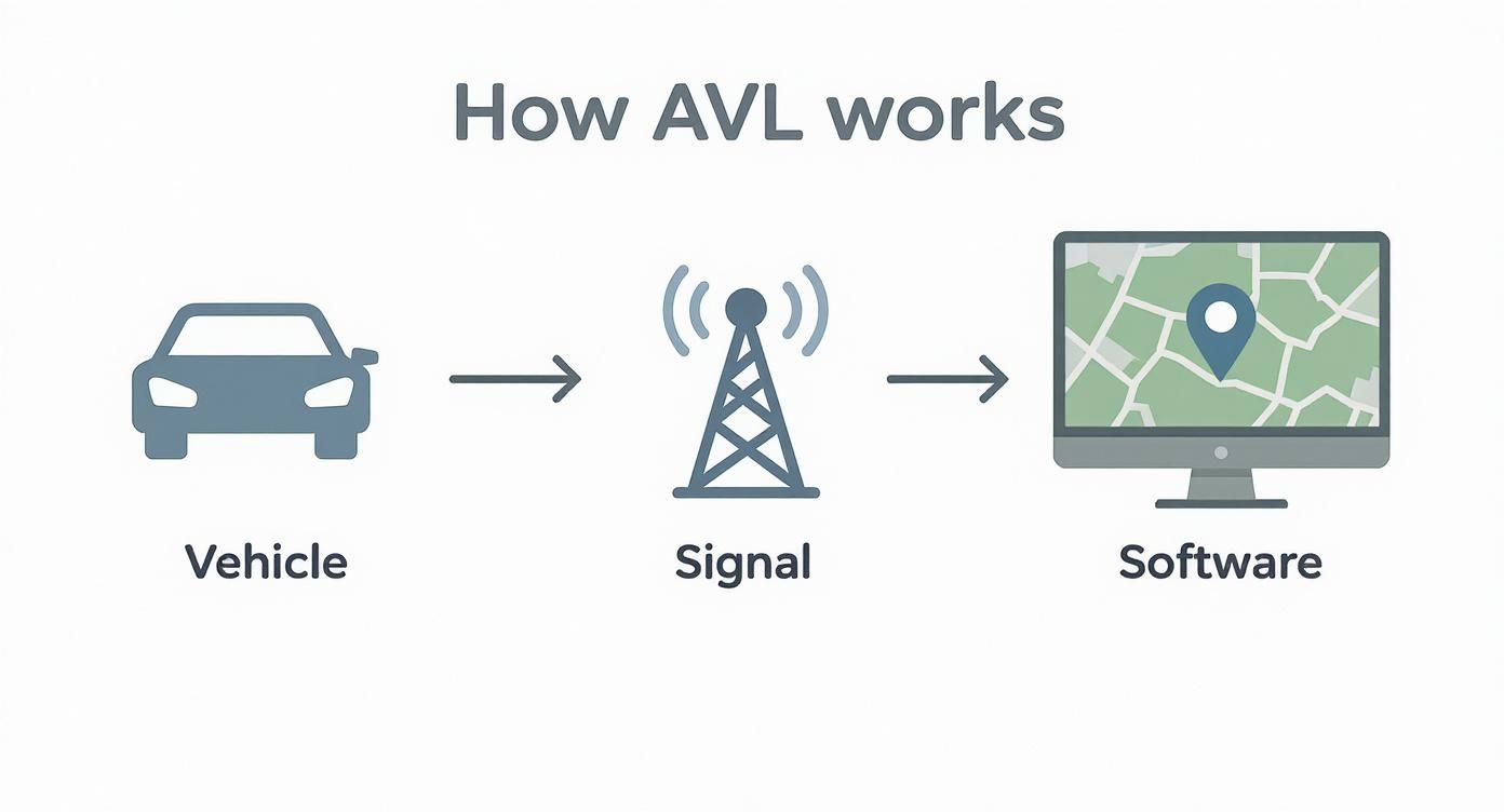
As you can see, it breaks down into three core stages: the vehicle gathers the data, the network transmits it, and the software turns it into something you can actually use.
Step 3: Unpacking and Displaying the Information
The final stop is where raw data becomes actionable intelligence. The central server gets this constant stream of coordinates and hands it off to the AVL software platform—the "recipient" in our analogy. This is the web dashboard or mobile app you’re looking at.
The software’s job is to "unpack" all that data and translate it into a simple, visual format. It plots the vehicle's location as an icon on a digital map, updates its position every time a new data packet arrives, and logs its historical path. This is how you see that truck or ambulance moving across your screen in what feels like real-time.
By transforming a constant stream of raw coordinates into an interactive map, the software provides a clear operational picture. This allows for immediate savings by enabling dispatchers to send the closest unit, reducing fuel waste and unnecessary mileage on every single call.
This three-part process—collect, transmit, and display—is the engine that powers every modern AVL system. It’s what turns simple location data into a powerful tool for boosting efficiency, enhancing safety, and cutting operational costs.
Key Features That Drive Real Savings
It’s one thing to understand the tech behind automatic vehicle location, but it's another thing entirely to see how it directly hits your bottom line. AVL is so much more than just watching dots move across a map; it's a powerhouse of features built to slash costs and make your operations run smoother. By turning raw location data into information you can actually use, these features start creating real savings from day one.
Let's break down the core functions that take an AVL system from a simple tracking gadget to a genuine money-saving asset for your entire organization.
Real-Time Tracking And Geofencing
The absolute foundation of any AVL setup is real-time tracking. Just knowing the exact location of every single vehicle at any given moment gets rid of all the guesswork and wasted time. A dispatcher no longer needs to make a dozen calls to find the closest unit; they can see the whole fleet on one screen and make an immediate, smart decision.
This isn't just about convenience—it's about efficiency. This single feature directly cuts fuel costs and trims down overtime by making sure the most logical unit is always the one sent to the job. It stops you from sending a vehicle from across town when another was just around the corner the whole time.
Geofencing takes this a step further. It lets you draw virtual perimeters around any location that matters to you—a job site, your primary service area, or even a restricted zone. The moment a vehicle crosses one of these invisible lines, the system can fire off an automatic alert.
- Practical Example: A fire department can set a geofence around a neighboring district's boundary. If an engine accidentally leaves its primary response area for a non-mutual-aid call, the battalion chief gets an instant text alert. This prevents coverage gaps and ensures resources stay where they are needed, potentially avoiding costly delays for the next emergency.
- Actionable Insight: Use geofencing to automate timesheets. Create a geofence around a major job site. The system can automatically log when a vehicle enters and exits, eliminating manual entry errors and providing precise, verifiable billing hours for clients, which prevents revenue loss.
Route Optimization And Driver Behavior Monitoring
Bad routes are a silent killer of budgets. They burn through extra fuel, rack up mileage, and put unnecessary wear and tear on your vehicles. Route optimization is the answer. It uses the AVL data to map out the most efficient paths, taking into account things like traffic, distance, and appointment schedules. It’s not uncommon for departments to see fuel consumption drop by 15-20% with this feature alone—a huge savings for any fleet.
Another game-changer is driver behavior monitoring. The AVL device in the vehicle is smart enough to pick up on and report unsafe or inefficient driving habits, such as:
- Harsh braking
- Rapid acceleration
- Excessive speeding
- Long periods of idling
This is about more than just playing "gotcha." Monitoring for things like harsh braking and jack-rabbit starts helps you pinpoint which drivers might need a bit of coaching. Getting those habits under control not only saves a surprising amount of fuel but also dramatically reduces maintenance costs on things like brakes and tires. On top of that, showing a commitment to safer driving can often help you get better insurance premiums.
By turning vehicle data into a performance report card, you can proactively manage your fleet's biggest expenses: fuel, maintenance, and insurance. It’s about making small, data-driven adjustments that lead to substantial long-term savings.
Comparing System Features For Maximum ROI
Not all AVL systems are built the same. They can range from the most basic trackers to incredibly advanced platforms with a ton of capabilities. The trick is to choose the right features to get the best possible return on your investment.
To help you sort through what you might need, here's a quick look at how basic and advanced features stack up.
Comparing Basic vs Advanced AVL System Features
| Feature | Basic System (Included) | Advanced System (Add-on/Premium) | Primary Money-Saving Benefit |
|---|---|---|---|
| Real-Time Tracking | ✓ | ✓ | Reduced fuel from efficient dispatching. |
| Geofencing | ✓ | ✓ | Automated timekeeping and asset security. |
| Route Optimization | ✓ | 15-20% reduction in fuel consumption. | |
| Driver Behavior | ✓ | Lower maintenance and insurance costs. | |
| Engine Diagnostics | ✓ | Proactive maintenance, preventing costly breakdowns. |
Many platforms, especially those built for first responders, pack in a wide range of functions. You can explore some of the advanced AVL features available on the Resgrid platform to get a feel for what’s possible these days.
Ultimately, truly understanding what automatic vehicle location is means seeing its potential beyond just tracking. It’s an operational tool that gives you the hard data you need to make smarter, more cost-effective decisions.
Practical AVL Use Cases for Fleets and First Responders
All the tech specs and theory in the world can't truly show you what Automatic Vehicle Location (AVL) is all about. You have to see it where the rubber meets the road. AVL isn’t just some background tech humming away; it's a dynamic tool that makes a real difference in high-stakes, time-sensitive jobs every single day.
From commercial businesses trying to stay profitable to public safety agencies where every second is the difference between life and death, the applications are both incredibly practical and powerful. These real-world situations show how organizations can move beyond just dots on a map to making smarter, faster, and more cost-effective decisions.
![]()
Driving Efficiency in Commercial Fleets
Let's imagine a busy plumbing company in the middle of a sweltering summer day. A frantic call comes in: a major pipe just burst at a commercial building, and it's flooding fast. Before AVL, the dispatcher’s job was a chaotic mess of phone calls. They'd have to start ringing up technicians one by one, asking where they are and guessing their ETA, just hoping they pick the right person. That process alone could burn 15 crucial minutes.
Now, with an AVL system, the dispatcher’s screen instantly paints a picture of the entire fleet spread across the city. They see that Technician B is just two blocks away, wrapping up a minor fix. With a single click, Technician B is dispatched to the emergency.
This isn’t just about making life easier; it’s about real, tangible savings:
- Reduced Fuel Costs: Sending the closest unit means a technician isn't driving clear across town, which saves a ton on fuel.
- Increased Productivity: That technician wastes zero time in transit, freeing them up to complete more jobs that day.
- Improved Customer Satisfaction: A rapid response turns a potential disaster into a moment where your company looks like a hero.
Actionable Insight: By analyzing historical route data, the plumbing company manager notices that technicians are consistently driving back to the central warehouse for a specific part. By stocking each truck with that part, they eliminate dozens of unnecessary trips per month, saving hundreds of dollars in fuel and gaining hours of billable time.
Enhancing Safety for First Responders
Now, let's switch gears to a public safety scenario where the stakes couldn't be higher. A 911 call reports a multi-car pileup on a busy highway. The dispatch center needs to get police, fire, and EMS to the scene—yesterday.
Without AVL, the dispatcher is flying blind, relying on voice chatter and memory to coordinate everyone. That can easily lead to confusion, delayed arrivals, and a dangerous lack of awareness on the scene. With AVL, the dispatcher has a complete, real-time command center view of every available asset.
In emergency response, situational awareness is everything. AVL provides a common operating picture, allowing a dispatcher to see not just where units are, but how to direct them for the safest and fastest multi-agency response.
The dispatcher can instantly spot the closest fire engine, the nearest ambulance, and the patrol cars in the best position to block traffic. They can guide units along the clearest routes, steering them around known traffic jams to ensure they all arrive in a coordinated, effective way. This shaves off critical seconds when it matters most and dramatically enhances officer safety by making sure everyone on scene knows who is where.
Practical Example: During a large wildfire, an incident commander can use AVL to see the real-time position of every engine and water tender. If the wind shifts suddenly, they can instantly identify and redirect units in the path of the fire, preventing them from being trapped and avoiding a potential tragedy. This level of oversight is impossible without live tracking.
The integration of AVL systems into fire apparatus, ambulances, and police cruisers has become an indispensable tool in modern public safety. For more insights on the market trends, you can explore the automatic vehicle location system market report at ExpertMarketResearch.com.
Putting an AVL System to Work, Step by Step
Bringing an Automatic Vehicle Location system into your organization might feel like a massive undertaking. The good news is, it doesn't have to be. If you break it down into clear, manageable stages, the whole process becomes much more straightforward. A well-planned rollout helps you sidestep common pitfalls, gets your team on board, and lets you start seeing a return on your investment almost immediately.
The first step, always, is to take a hard look at your operational needs. This isn't about the tech just yet; it's about figuring out your pain points. Are you trying to get a handle on soaring fuel costs? Is the goal to tighten up dispatch efficiency and improve response times? Or is it all about enhancing the safety and accountability of your people in the field?
Nailing Down Your Needs and Vetting Providers
Before you even glance at a single vendor's website, get specific about what you need the system to do. This internal audit is the most critical part of finding a solution that actually fits your goals and your budget.
Ask yourself these key questions:
- What's our number one goal here? Are we laser-focused on cost savings (fuel, maintenance), slashing response times, or ensuring we know where our people are at all times?
- What are our absolute "must-have" features? Is basic real-time tracking enough, or do we need advanced tools like geofencing and alerts for unsafe driving behavior?
- Do we need to tap into engine diagnostics? Getting a heads-up on maintenance issues can prevent costly breakdowns and vehicle downtime. It's a huge money-saver.
- What’s our real budget for hardware and the monthly service? Be realistic about both the upfront investment and the ongoing operational costs.
Once you’ve got a clear picture, you can start looking at providers. Don't let the price tag be your only guide. Demand a transparent pricing model and ask pointed questions about contract lengths, installation fees, and any other potential hidden costs. You don't want any surprises down the line.
Getting Installed and Training the Team
After you've picked a provider, it's time for the hardware installation. A lot of modern AVL devices are simple "plug-and-play" units that connect right into a vehicle's OBD-II port. This makes installation a quick job you can often handle in-house. For more complex hardwired setups, professional installers are always an option.
The GPS-based AVL segment is the most widely used for a reason—it's accurate, reliable, and cost-effective, and it's expected to stay on top for the foreseeable future. You can dig into the specifics in the automatic vehicle location market forecast on ExpertMarketResearch.com. This market dominance means you'll have plenty of high-quality, road-tested hardware to choose from.
The final, and arguably most important, step is team training. Your AVL system is only as good as the people using it. Solid training ensures everyone—dispatchers, drivers, and managers—understands how to use the software and, more importantly, sees the value in it.
Show your team how this system makes their jobs easier, not harder. A dispatcher can find the closest unit in a heartbeat. A driver can get optimized routes to save time and frustration. Emphasize that the goal is efficiency and safety, not playing Big Brother. Many platforms are built with a more intuitive interface, like Resgrid's suite of dispatch and management apps, which are designed to be easy to pick up. A smooth training process builds buy-in from day one and gets you that much closer to a strong ROI.
A Few Common Questions About AVL
When you start digging into automatic vehicle location and what it can do for your department, a few key questions always seem to pop up. Getting straight, practical answers is the only way to make a good call. So, we'll tackle the most common things managers ask when they're thinking about bringing in an AVL system.
Our goal here is to cut through the jargon and give you answers that make sense for both your operations and your budget. Let's get into the details that really matter.
How Much Does An AVL System Actually Cost?
The investment in an AVL system usually breaks down into three pieces: the upfront cost for the hardware, a monthly subscription for each vehicle, and sometimes a one-time fee for installation. You can expect the hardware to run anywhere from $50 to $200 per unit, with monthly plans typically landing between $15 and $40 per vehicle.
But the real story here isn’t the price tag—it’s the return you get on that investment. The best way to look at the monthly fee is as a tool that pays for itself. Think about it: if a $25/month subscription saves your department $50 in fuel and overtime because your dispatching is sharper, you're already getting a 100% return.
The bottom line: When you're talking to vendors, insist on seeing a completely transparent pricing list. This is how you sidestep surprise fees for things like data overages or "premium" features that can get buried in the fine print, making sure the ROI you planned for actually happens.
What Happens If a Vehicle Loses Cell Signal?
This is a classic operational headache, and it's one that modern AVL systems are built to solve. Most quality GPS trackers use what’s called "store-and-forward" technology. When a vehicle drives out of an area with cell service, the device doesn't just give up. It keeps collecting and saving location data right on the unit.
As soon as that vehicle gets back into cell range, it automatically pushes all that saved data back to the server. For crews that are consistently working in remote areas, there are also devices that use satellite communication for 100% uninterrupted tracking, though they do come with a higher monthly bill.
What About Privacy Concerns?
The main privacy issue that comes up is tracking employees when they’re off the clock. The best way to handle this is head-on with clear communication and a solid, formal policy.
Put together a written vehicle tracking policy and make sure every single person on staff gets a copy and acknowledges it. The policy should state, in no uncertain terms, that tracking is only active during work hours and is used for specific operational reasons like safety, efficiency, and dispatching. For a more detailed look at how we handle data, you can check out the Resgrid privacy policy.
A lot of advanced AVL systems also have a "privacy mode" that drivers can turn on when they're off duty. It’s a simple feature, but it goes a long way toward building trust and showing respect for personal time while keeping operational oversight right where it needs to be.
Ready to transform your dispatching and fleet management? With Resgrid, you get a powerful, intuitive AVL solution designed for the real-world demands of first responders and businesses. See exactly where your assets are, make smarter decisions, and improve response times—all from a single, easy-to-use platform. Learn more and get started with Resgrid today.