
Common Operational Picture: Guide for First Responders 2026
If you're running dispatch, command, or multi-agency coordination today, you already know the feeling of operating half-blind. Units are en route, radio traffic is stacked, one agency is looking at CAD, another is looking at text threads, and somebody is still asking for the latest staging location because the answer changed three minutes ago. That kind of friction doesn't just slow the job down. It burns fuel, extends scene time, drives overtime, and creates expensive mistakes.
A common operational picture fixes that problem when it's done right. Not by adding another screen to ignore, but by giving everyone the same operational view at the same time. In the field, that means fewer duplicate assignments, faster route changes, cleaner handoffs, and less time spent reconciling conflicting information. For leaders watching budgets tighten, that's the compelling argument. A COP isn't just a coordination tool. It's a cost-control tool that improves service while cutting waste that most agencies have accepted as normal.
From Chaos to Clarity The Power of a Single View
A highway pileup is one of the clearest examples. Fire is blocking lanes, EMS is trying to sort patient counts, law enforcement is pushing for traffic control, towing wants access points, and dispatch is juggling updates from callers who all describe the scene differently. Without a shared view, the same incident gets managed through fragments. One supervisor is working from radio traffic. Another is looking at a map that isn't current. Field crews hear one staging instruction, then another.
That kind of response feels busy, but a lot of the work is corrective. Units get reassigned after arrival. Apparatus approach from the wrong side. Supervisors ask for updates that someone else already had. Every one of those failures has a cost attached to it.
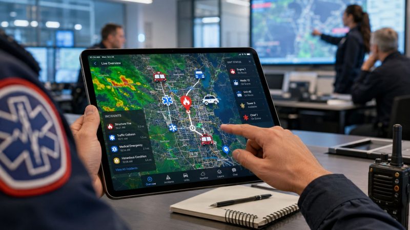
Now run the same incident with a COP in place. Dispatch drops the incident on a live map. Unit locations update as crews move. Closures, hazards, access points, and staging areas are visible to the same group in real time. The battalion chief, EMS supervisor, law enforcement command, and dispatch center aren't piecing together separate versions of the event. They're operating from one picture.
A practical example is a live operations map that shows unit movement, incident markers, and changing scene conditions in one place, such as Resgrid's mapping feature. The point isn't the vendor. The point is operational alignment. When everyone can see the same incident footprint, command spends less time correcting misunderstandings.
Field reality: Most incident confusion isn't caused by lack of effort. It's caused by teams working from different versions of the truth.
The concept didn't start in civilian public safety. It came out of military command-and-control practice, where the common operational picture evolved as a shared display of relevant information for coordinated action. That model has been discussed for about two decades, and U.S. Army modernization reported the CPOF system was fielded to 95% of the Army with almost 20,000 systems deployed, showing how broadly the concept was operationalized in practice, as summarized in the Common operational picture overview.
What Exactly Is a Common Operational Picture
A common operational picture isn't just a map with icons on it. It's a standardized, continuously updated overview that pulls in data from multiple sources so incident commanders and supporting agencies can make effective, consistent, and timely decisions, as described in this public safety explanation of a common operating picture.

Think of it as a live shared game map
The easiest way to explain it is a multiplayer strategy game. Every player sees the same map. Everyone can spot the same changes. If one player discovers a threat or moves resources, the rest of the team can react immediately because the information is shared.
That's what a COP does in real operations.
If police sees a road closure, fire shouldn't learn about it ten minutes later over the radio. If EMS establishes a treatment area, command and dispatch should see it without waiting for a relay chain. If emergency management adds weather or evacuation information, the rest of the response structure should be able to use it right away.
What belongs in the picture
A useful COP usually brings together operational details such as:
- Incident locations: Active calls, perimeters, staging, triage, shelter, or command posts.
- Resource status: Unit location, availability, assignment, and movement.
- Environmental inputs: Weather, traffic impact, camera views, or airspace concerns when applicable.
- Shared notes and decisions: Hazards, ingress and egress routes, closures, and priorities.
The critical point is that the picture has to stay current. A static dashboard isn't a common operational picture. It's just a reference board.
A stale display can be more dangerous than no display at all, because crews trust information that no longer matches the scene.
Why the definition matters financially
A lot of agencies buy software based on features and end up with a screen that looks impressive but doesn't change operations. If the display isn't continuously updated and shared across the people making decisions, it won't reduce waste. You'll still have duplicate dispatching, unnecessary calls for clarification, and prolonged incidents because command has to rebuild the situation manually.
The money-saving value comes from one thing. Fewer bad decisions caused by delayed or conflicting information.
The Core Components of an Effective COP
An effective COP stands on four parts. If one is weak, the whole system becomes expensive window dressing.

Data sources that operators trust
The first requirement is input. A COP has to absorb the systems people already use, including CAD, AVL, cameras, weather feeds, and other incident-related data. If crews have to leave the COP and go hunt for the actual information elsewhere, adoption drops fast.
A practical example is unit location data. If your AVL feed is reliable, command can see where coverage gaps are forming, which units are closest, and whether a reassignment makes sense before someone says it over the air. That's where tools like AVL unit tracking matter. Real-time location isn't a novelty. It's what prevents avoidable cross-town moves and late corrections.
Visualization that supports decisions
Raw feeds don't help by themselves. The second layer is how the data appears. The display has to make priorities obvious. Operators need to spot active incidents, hazards, unit movement, and bottlenecks without squinting through clutter.
A good visualization answers questions quickly:
| Operational question | What the COP should show |
|---|---|
| Where is the incident growing? | Perimeter, markers, hazard updates |
| Which units can respond next? | Current location and availability |
| Where should incoming resources stage? | Shared staging points and access routes |
| What changed in the last few minutes? | Live updates, status changes, new notes |
A bad interface creates its own cost. Crews spend more time asking for confirmation, and supervisors revert to side channels because the screen isn't helping.
Collaboration tools that reduce radio traffic
The third piece is collaboration. Shared markers, notes, status changes, and direct updates on the map save time because they cut out repetition. A dispatcher who marks a new staging area once shouldn't have to repeat it to every agency separately.
Trust in COP projects is earned or lost through the usability of their tools. If the collaboration tools are fast and intuitive, teams use them under pressure. If they require too many clicks or too much cleanup, people go back to voice and text fragments.
Operational rule: If an update takes longer to enter than to say on the radio, crews won't keep the COP current.
Access control that matches the real chain of work
The last component is role-based access. Not everybody needs the same detail, and showing everything to everyone creates noise. A supervisor may need broad scene awareness. A dispatcher may need unit status and queue impact. A field operator may need only route, assignment, and hazard information.
When leaders evaluate platforms, this is the checklist that matters most:
- Can it ingest the data you already depend on?
- Can operators read it quickly under stress?
- Can teams collaborate inside the same view?
- Can access be controlled by role, agency, and function?
If the answer to any of those is no, the COP will look better in a demo than it performs in an incident.
Key Benefits That Justify the Investment
Most agencies don't struggle to understand the operational value of a common operational picture. The harder question is whether it pays for itself. In practice, it does when it reduces three common drains on the budget: slow response, poor resource allocation, and preventable errors.

Faster response cuts labor drag
When dispatchers and command staff stop reconciling multiple systems by hand, work moves faster. One independent industry analysis reported that consolidating fragmented data intake into a unified COP reduced critical response times by 34% and improved SLA adherence from 60% to 94% within a 90-day implementation window, according to NUAIR's discussion of unified COP operations.
That matters financially even if your agency doesn't measure SLA in the same way. Faster response usually means shorter incident duration, fewer cascading delays, and less time with excess resources committed longer than needed.
Better resource assignment prevents waste
The hidden cost in many responses isn't dramatic failure. It's overcommitment.
A unit gets sent "just in case" because nobody is fully certain what else is already moving. Mutual aid is requested early because the current picture is incomplete. Supervisors hold units on scene longer because they can't confirm downstream status. That adds fuel use, vehicle wear, and staffing costs without improving the outcome.
A COP helps by making assignment decisions cleaner. The nearest appropriate unit becomes visible. Staging locations are shared. Coverage holes are easier to anticipate. That means fewer unnecessary moves and fewer times command sends resources to compensate for uncertainty.
Fewer errors save more than speed does
Operational mistakes are expensive. Wrong-side approach. Duplicate dispatch. Unclear perimeter. Late recognition that two agencies are solving the same problem separately. None of these errors needs a catastrophic ending to cost money.
Consider the difference below:
| Without a COP | With a COP |
|---|---|
| Two supervisors request overlapping resources | Shared status makes overlap visible |
| Units arrive at different access points | Common route and staging markers align arrival |
| Dispatch fields repeated status checks | Shared display answers routine questions |
| Agencies build separate maps | One operational picture supports joint action |
Safety and finance are connected
Responder safety always comes first, but it also has a budget dimension. Better awareness of hazards, personnel locations, and backup availability lowers exposure to preventable risk. Even when nothing goes seriously wrong, cleaner operations reduce the soft costs that pile up after every messy incident. Extra reporting, rework, disputes over timeline, and strained mutual-aid relationships all carry a price.
The strongest business case for a common operational picture is simple. It reduces the cost of confusion.
A Practical Roadmap for Implementing a COP
Most COP rollouts fail for ordinary reasons. Too much data too soon. No agreement on who owns updates. A display built for executives instead of operators. The right way to implement one is to run two tracks at the same time: technical and organizational.

Technical steps that make the system usable
Start with the incident types that create the most friction. Multi-vehicle crashes, structure fires, severe weather operations, planned events, or countywide mutual aid are common choices because they expose coordination gaps quickly.
Then build the first version of the COP around the feeds that matter most:
Select a platform that can support live operations
Pick something that can present a shared map, unit status, and incident updates without forcing staff into a completely new workflow. If dispatch coordination is central to your operation, evaluate whether the platform can support that work directly, such as dispatching workflows for live incident management.Integrate only the highest-value data first
Start with CAD, AVL, and a small set of map layers or camera inputs. Most agencies get into trouble by trying to connect everything at once. Early success comes from making the core picture accurate and dependable.Configure views for real users
A battalion chief doesn't need the same screen as a call taker. A field supervisor doesn't need the same level of detail as an emergency operations center. Build the display around decisions, not around available widgets.
One option agencies may consider is Resgrid, LLC, which provides mapping, dispatching, personnel tracking, messaging, and reporting in one platform. The useful question isn't whether any platform has a long feature list. It's whether operators can keep the shared picture current during actual incidents.
Organizational steps that determine adoption
The human side usually decides whether the COP becomes part of operations or just another monitor on the wall.
A mature setup separates the broad shared view from role-specific detail. In control-room practice, the Common Operational Picture acts as the shared overview, while the Personal Operational Picture delivers task-specific intelligence at each workstation, reducing cognitive load while preserving tactical detail, as explained in this overview of COP and POP in control-room operations.
That distinction matters because too much information kills usability.
What to lock down early
Use a short governance checklist before launch:
- Define update ownership: Decide who updates staging, closures, hazards, and status changes.
- Set role permissions: Limit edit rights where needed, but don't block essential sharing.
- Write SOP triggers: Specify when the COP becomes the primary shared picture for an incident type.
- Train by scenario: Use short drills based on common calls, not classroom-only walkthroughs.
- Review after every major incident: Ask what data stayed current, what lagged, and what operators ignored.
The most reliable COPs aren't the ones with the most layers. They're the ones crews can maintain while the incident is still moving.
Start narrower than you want
A smart rollout might begin with one center, one partner agency, and one recurring incident type. Once that team builds trust in the picture, you expand. That approach saves money because it limits integration work, exposes policy gaps early, and avoids a full-scale launch that staff gradually abandon after the first difficult week.
Common Challenges and Mitigation Strategies
The biggest mistake leaders make is assuming the main challenge is software. Usually it isn't. The hard part is getting multiple systems, policies, and habits to produce one trusted view.
Interoperability breaks first
A COP has to integrate disparate sources like CAD, AVL, and cameras while also enforcing access permissions across jurisdictions. Its value depends on whether the organization can keep data current, permissioned, and trusted while several agencies contribute at once, as discussed in Juvare's guidance on common operating picture implementation.
That's where many projects stall. One feed updates every few seconds. Another arrives late. A third isn't normalized, so the labels don't match what field users expect.
Mitigation is straightforward, even if it isn't glamorous:
- Start with authoritative systems: Use the feeds that operators already trust most.
- Create one naming standard: Unit names, locations, and status labels need to match across agencies.
- Assign a data owner: Every live layer needs someone responsible for its quality.
Information sharing gets political
Agencies often say they support shared visibility right up until access rights are being configured. Then old issues surface. Who can edit what. Who sees tactical details. Which agency owns the map during unified command.
A practical fix is a small pilot with a narrow objective. Pick one incident category, define a shared operating need, and document the value gained. When agencies see a COP reduce confusion in a real event, policy conversations become easier because the benefit is concrete.
Shared visibility works only when agencies agree that better coordination matters more than owning every piece of information.
Training usually gets underfunded
No one ignores a COP on purpose. They ignore it because they don't trust it yet, or because updating it feels like extra work during a busy operational period.
The mitigation isn't longer policy documents. It's repetition under realistic conditions.
Try this approach:
| Challenge | Mitigation |
|---|---|
| Staff forget to update the picture | Build COP tasks into dispatch and command checklists |
| Operators don't trust the map | Use drills that compare COP data to real field conditions |
| Agencies revert to side channels | Require key decisions and markers to be logged in the shared view |
When training is tied to actual incidents and role-specific tasks, the COP becomes part of the workflow instead of a side project.
How to Measure the Success of Your COP
If you can't show what changed, budget conversations get hard fast. A common operational picture should be measured by operational outcomes that have financial consequences, not by how many screens were installed or how many layers were turned on.
Measure the things that cost you money
Track a small group of indicators before and after deployment:
- Average response handling time: Look for less delay between call intake, assignment, and arrival coordination.
- Time on scene per unit: Shorter scene times often signal cleaner coordination and fewer duplicate tasks.
- Resource allocation errors: Count wrong-type dispatches, duplicate assignments, and unnecessary moves.
- Cross-agency clarification traffic: Watch for reductions in repeated status checks and location confirmation.
- Overtime pressure after complex incidents: Even a qualitative drop matters if command is releasing resources earlier and with more confidence.
Pair numbers with after-action evidence
Not every benefit shows up cleanly in a dashboard. Some of the strongest proof comes from after-action reviews. Ask command staff and dispatch supervisors whether they made fewer calls to verify the same information, whether staging changes spread faster, and whether mutual-aid coordination required less manual cleanup.
A COP is working when decision-making becomes less expensive. Crews spend less time waiting, supervisors spend less time reconciling conflicting updates, and incidents close with fewer avoidable detours. That's the ROI most agencies should care about.
If your team needs a practical way to build a shared operational view without adding contract-heavy complexity, Resgrid, LLC offers mapping, dispatching, personnel tracking, messaging, and reporting in one platform for first responders, dispatch centers, public safety agencies, and organizations that need live operational coordination.